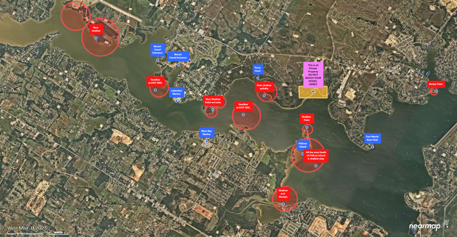
Five feet below Conservation aka 644' MSL is not as big an issue as some on social media have made it out to be with respects to recreation on beautiful Eagle Mountain Lake. Sure five feet down is a substancial issue for those who may have boat docks in areas that historically have issues when the lake drops...but for most recreation, especially that associated with the up-coming Labor Day Holiday it's not that bad.
Why? The two major "sand bars" (if one uses that terminology) are at roughly 640' MSL. One is located just North of Lakeview Marina on the North side of Gilmore Creek slough as one heads North out of Gilmore slough. It extends way farther West into the lake than most people realize, so watch your depth finder. The second major "sand bar" is the one more people are familar with that lies due West of Party cove. Again....assuming the lake is five feet low and these two sand bars are, for the most part, around 640' MSL that means that there is a good chance that the water depth over those sand bars is roughly four feet today. Yes, if you're in a big boat that drafts 4-5 feet or you attempt to cross these sand bars in a wake/surf boat with all balast tanks full and 14 people on board, then you're likely to shine your prop or perhaps bend it! But for the most part, four feet of water over these two natural obstacles is workable. And, if the lake continues to drop...just beware of these two sandbars and go around them!
Having lived on, or close by, Eagle Mountain Lake since 1974 and operating two marinas on this lake for many years I have personally seen Eagle Mountain Lake go through several cycles of high and low water issues. And, while I would rather see the lake at around two feet low....five feet low is plenty workable. Additionally, I am an advocate of the way the TRWD has spent time and money helping keep Eagle Mountain Lake as constant level as it possibly can considering mother nature and the population growth in North Texas over the last 50 years. So, if you want to believe in what Chat GPT might offer...please note the following (in blue) with respects to where the water in EML is going....especially this time of year!
So for a conceptual ranking of where Eagle Mountain water goes, I would use:
| Rank | Use / loss | Approx. share | Confidence |
|---|---|---|---|
| 1 | Municipal / residential & commercial | ~70–75% | High that it dominates; % estimated |
| 2 | Evaporation | ~20–25% | High |
| 3 | Industrial / manufacturing | ~3–5% | Moderate; estimated allocation |
| 4 | Irrigation / agriculture | ~1–2% | Moderate-low |
| 5 | Fracking / oil & gas (mining) | <1% | High that it is small; exact lake share uncertain |
Those percentages should be presented as approximate, not as an audited Eagle Mountain water budget. The reason I am more comfortable with the ranking than the exact percentages is that TWDB's water-use records categorize municipal, manufacturing, mining, irrigation, etc., but don't give us a simple published table saying exactly what percentage of Eagle Mountain Lake withdrawals went into each category.
Average evaporation is about 37,500 acre-feet per year. That's roughly 12.2 billion gallons of water annually.
TRWD itself notes that on a very hot day, Eagle Mountain's evaporation loss can equal the amount being withdrawn by the water-treatment plant.
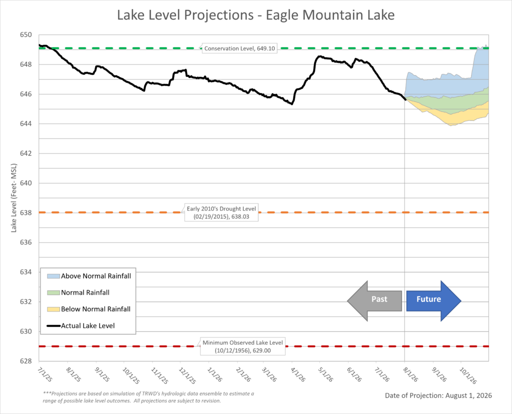
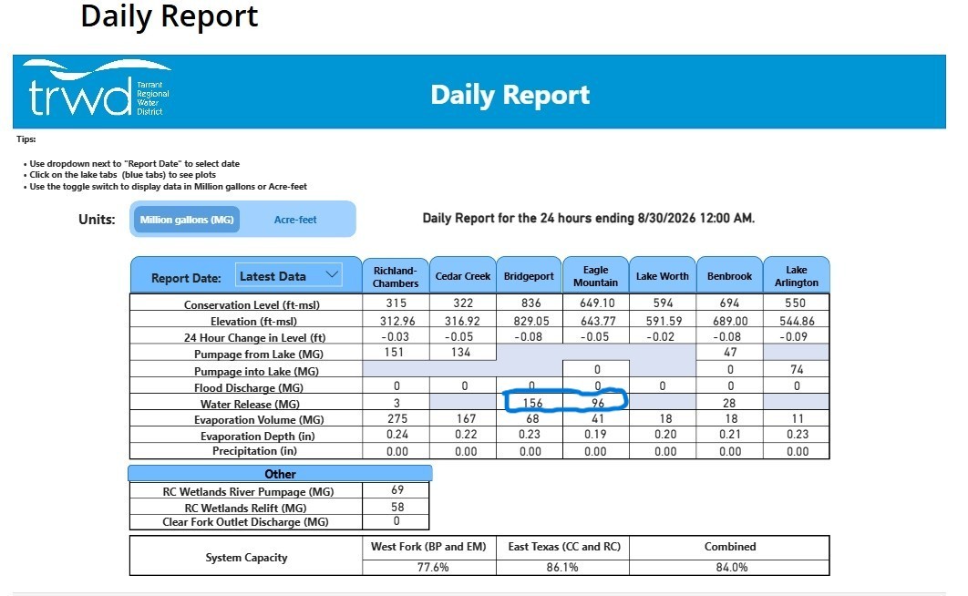
I have also attached a couple of screen shots off the TRWD website that I think are important leading into the months of September and October. The first of which is the latest EML lake level projection dated 8-1-2026. I expect another will come out in a few days...but as you can see this one is projecting the lake to be possibly a little more than five feet low in the coming weeks. The next screen shot supports that by showing that Lake Bridgeport is releasing about 60 (MG) a day more than what EML is releasing, and this delta has been maintained for several days now. This, based on my years of watching this type of water management by the folks at the TRWD, is entirely consistant with their past actions due to the fact that Lake Bridgeport is only about seven feet low currently.
Lastly please study this satellite map of EML when is was about three-four feet low. It shows where the potential danger spots are on EML as the water level drops. Again, not all areas noted are critical at five feet low, but it is always a good idea to know where the trouble spots are and avoid the shallower areas even when the lake is only two or three feet low.
I hope this helps and everyone enjoy beautiful Eagle Mountain Lake this Labor Day Holiday and the cooler Fall weather!